Call for Papers
The scientific committee especially welcomes paper proposals with new historical contributions from scholars in fields whose work relates with the following topics (but not limited to):
- Cabrilho’s expedition interactions with native Americans — the knowledge gained about their early lives and populations.
- Naturalization of foreigners in the Spanish Americas.
- Juan Rodríguez Portugués and homonyms
- Cabrilho’s Portuguese, Spanish, and American families, friends, and business, and respective socio-geographical context, in particular relating to Mount Cabrilho and Lapela de Cabril in Portugal.
- Cabrilho and Villalobos fleets and respective vessels: from construction to final end.
- Antonio de Herrera y Tordesillas, Joan Paez, Urdaneta and other Spanish sources.
- Alvar Nunes, Gaspar Rico (Villalobos’ pilot-major), Martim da Costa (Hernando de Grijalva’s pilot, under Cortés), Antonio Correia, and other Portuguese pilots, shipmasters and shipowners in the Spanish Americas.
- The importance of Portuguese naval carpenters in Central America and New Spain: from, e.g., Sebastião Alvares and António Fernandes in Panama and perhaps Nicaragua, to Fernão Dias in the early construction of Cortés’ ships.
- Nicaragua as a rotating door for Mar del Sur, Francisco Raposo (as in the Colombian Raposo territory), and the presence of several other Portuguese in Nicaragua and neighboring El Salvador, Honduras, and Guatemala.
- Bartolome Ferrer (Cabrilho’s pilot-major), Jeronimo Sant Remo, Lorenço Barreda and other Genoese and Corsican pilots, shipmasters, shipowners, and naval carpenters, related to Cabrilho and other Portuguese in the Spanish Americas.
- Spanish sailors, like the Basque pilot Juan Acurio (survivor of Magalhães’ expedition) that may have been in Cabrilho’s fleet.
- Portuguese pilot Sebastião Rodrigues Soromenho and his exploration of California’s coast in 1595.
- Drake and his Portuguese pilots (real as Nuno da Silva, or perhaps fictitious as N. Moreira) as well as the role of Cavendish in bringing new Californian cartographic data to Europe.
- The travels of the first woman-admiral of the Pacific, the Portuguese Isabel Barreto, and her working relation with the Portuguese pilot Pedro F. de Queiroz: the exploration of the Solomon Islands, the discovery of Vanuatu (Australia of the Holy Spirit), etc.
- The return trip between the Philippines and Mexico by the Afro-Portuguese pilot Lope Martim de Lagos and his friend João Eanes, in 1564-1565, and subsequent voyage.
- Cartography and toponyms of the Pacific, from Manuel Rodrigues’ shoals, to Gaspar Rico island, Gaspar Rico Cape in Papua New Guinea, etc.
- Trans-Pacific interactions, such as the echoes in China and Japan of the mapping of California, as well as the participation of the Portuguese oriental territories and mariners in the Manila galleon route during the Iberian union of crowns.
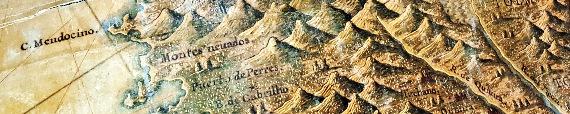
- Matteo Neroni’s cartographic work and the Bay of Cabrilho.
- Matteo Neroni’s Florentine context: connections with Matteo Ricci and the Portuguese Jesuits in Asia; the Florentine merchant Francesco Carletti, and his completion of the first private voyage around the world in 1602; the preparatory context of Ferdinando de Medici’s “British” expedition to Guyana and Brazil in 1608-1609.
- Gabriel Tatton’s cartography of California
- Cavendish and Molyneux’s 1592 (first ever English) globe with other Portuguese words toponyms over Alta California.
- Simão Fernandes (the Portuguese pilot-major of Roanoke Island) and Pacific sources for English cartographers
- Portuguese cartographer Bartolomeu Lasso connection to Dutch cartographers; the presence of the Flemish cartographer Jodocus Hondius in England, and Tatton and Molyneux in Holland. The importance of the Dutch and Flemish Pacific cartography.
- Very earlier maps of California (like the 1559 map, of the Portuguese cartographer André Homem) and Lopez de Gomara’s early description of California’s toponyms.
We expect the conference will be held fully in person (possibly with a few exceptions for remote participants).
Applicants should submit a title and a 300 words (max.) proposal along with a C.V.
by August 15, 2024, writing
to [email protected].
![]()
A special thank you to
![]()
With the sponsorship of
![]()
![]()
![]()
![]()
![]()
![]()
![]()
![]() Kenny Alameda
Kenny Alameda
 San Diego
Sacramento
![]()


𝓙𝓸𝓮 & 𝓜𝓪𝓻𝓵𝔂 𝓭𝓪 𝓡𝓸𝓼𝓪 𝓪𝓷𝓭 𝓕𝓪𝓶𝓲𝓵𝔂
𝓙𝓸𝓱𝓷 𝓡𝓮𝓫𝓮𝓵𝓵𝓸
𝓒𝓱𝓻𝓲𝓼 𝓭𝓪 𝓡𝓸𝓼𝓪
𝓕𝓲𝓵𝓸𝓶𝓮𝓷𝓪 𝓪𝓷𝓭 𝓘𝓭𝓪𝓵𝓶𝓲𝓻𝓸 𝓭𝓪 𝓡𝓸𝓼𝓪
Top Banner Photo: A California's 1604 map, based on Spanish sources, by Florentine
cartographer Matteo di Jacopo Neroni da Peccioli. At the bottom left, near the coast,
around 40 degrees north, it remarkably shows the toponym "B. de Cabrilho" (sic) [Bay
of Cabrilho]. Courtesy of the French National Library.